102,436 Hectares of Prey Lang Were Converted into Agricultural Land and Resettlement Areas in the Last Two Decades
10 August 2020 – A study authored by the Ecology Program of Jesuit Service Cambodia (JSC), in partnership with Cambodian Youth Network (CYN), of the change in forest cover in the Prey Lang Protected Area compared satellite imagery taken in the year 2000 and 2019, and found that 102,436 hectares of forest became barren or were converted into crops, plantations, and human settlement areas during that time period. This number of hectares represents around 24% of the total land area of Prey Lang, making it a very significant phenomenon.
Making use of QGIS, a geographic information system software, analyzed satellite images taken during the years 1999, 2000, 2018 and 2019 (Landsat 5 and Landsat 8) with a spatial resolution of 30m, we created a change detection map with corresponding statistics on forest loss and gain, referring to the current forest extent within the boundary of the protected area. Our findings include:
-
- forest loss of 102,436 ha, which includes 58,138 ha that were converted from forest to plantations
- forest gain of 1,111 ha, which means this amount of hectares that was previously non-forest in 2000 became standing forest in 2019
- forest cover of 302,106 ha in 2000 still remained in 2019
It was also decided not to count plantations under the category of “forests”. Although we are aware that the UN Food and Agriculture Organization includes tree plantations when measuring forest cover, we agree with numerous organizations around the world that declare true forests as those which support biodiversity, display functioning ecological systems, and possibly have interdependent relationships with local communities.
In terms of overall accuracy of the change detection maps of Prey Lang’s image classification output, we found it to be 96.43% with a kappa coefficient of 0.95, giving us a high degree of confidence about the findings.
Some limitations of the study include: although secondary data was used for training and validation together with actual collection of GPS readings of ground cover, more extensive ground-truthing to confirm the results is warranted to further increase confidence in the results. Also, since the study focused on only two time periods (2000 and 2019), information on the changes that occurred during the years in between cannot be given.
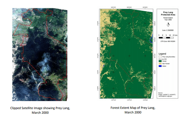
Land Classification |
Area (hectares) as of March 2000 |
Forest |
404,542 |
Non-forest (either has an agricultural cover planted to crops or has a barren surface or human settlement areas and water) |
28,933 |
Plantation (areas with trees but not naturally occurring as this was propagated by humans, since there is spacing interval or pattern between trees and not randomly growing like what appears in nature) |
0 |
Water |
2 |
Total |
433,477 |
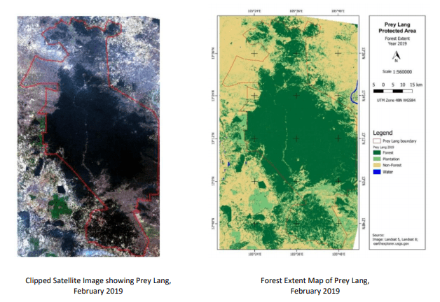
Land Classification |
Area (hectares) as of February 2019 |
Forest |
303,216 |
Non-forest (either has an agricultural cover planted to crops or has a barren surface or human settlement areas and water) |
72,121 |
Plantation (areas with trees but not naturally occurring as this was propagated by humans, since there is spacing interval or pattern between trees and not randomly growing like what appears in nature) |
58,138 |
Water |
2 |
Total |
433,477 |
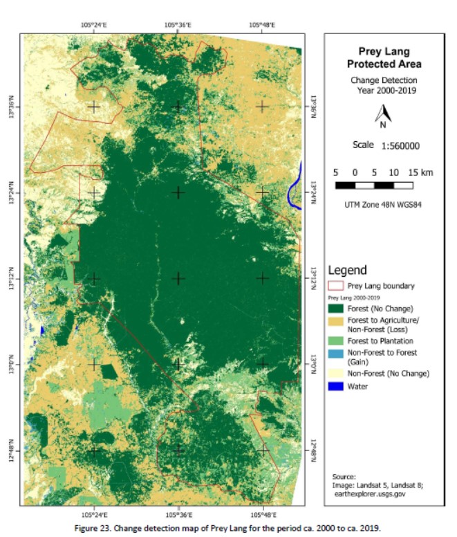
Class categories for the change detection of forest cover |
Area (hectares) as of February 2019 |
Forest (No Change) |
302,105 |
Forest to Agriculture |
44,298 |
Forest to Plantation |
58,138 |
Non-Forest to Forest |
1,111 |
Non-Forest (No Change) |
27,823 |
Water (No Change) |
2 |
Total |
433,477 |
Contacts:
- Liesl Lim, Program Manager of Ecology Program, Jesuit Service Cambodia
Tel: 086 291 237 Email: jesecam.eco@gmail.com
- Sar Mory, Research and Advocacy Program Manager of Cambodian Youth Network
Tel: 016 930 588 Email: mory@cyncambodia.org